Version 0.5 Released
Now including maps and stats!
If you have already installed the extension it should update soon, if not you can get it from the Chrome WebStore today!
It has been a couple of months since our last release, but we haven’t been twiddling our thumbs in that time…
The two big features in this version are the addition of maps to most challenges (with regionnaire being the biggest exception, but more on that later), and the inclusion of a brand new section at the top summarising lots of stats to get your inner geek salivating!
Stats
The stats are displayed above the challenges, and just under the athlete stats that are provided by default on the parkrun website. Here we summarise some of the main pieces of information that parkrun tourists and stats geeks love to have, such as:
- How many different events have I actually attended?
- What is the total distance I have run?
- What percentage of parkruns attended have been parkrun events I haven’t been to before?
- What is the total travel distance between each of the parkrun events I have done?
Most of the stats are available on everyone’s page, which means that you can browse these details for other people just like on your own page, but there are are a few exceptions. If you have configured your home parkrun and athlete ID in the extension’s options page, then you will also get two additional stats to answer the questions:
- What is the nearest event I haven’t done yet?
- Which is the furthest away parkrun event I have been to?
Maps
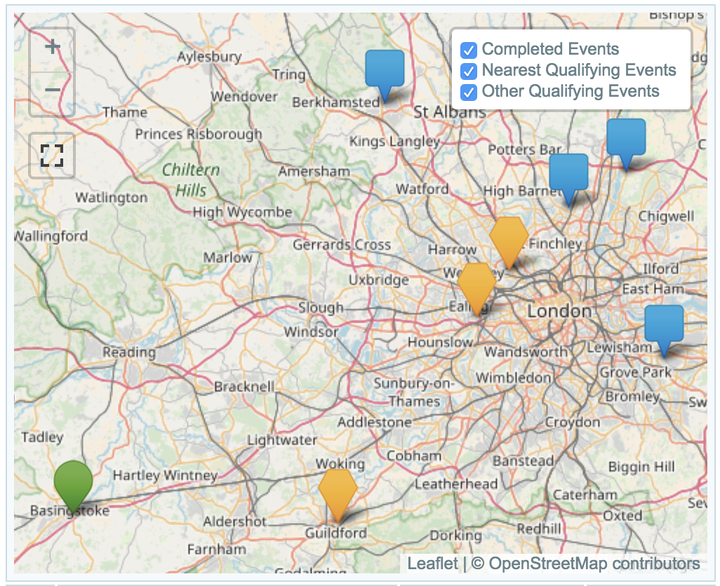
Many of the challenges involve visiting specific parkruns - many are based on their name (e.g. the initial letter, or containing a word), but there are also those such as the Cowell Club that look for number of unique events. To help see where you have been, and perhaps help you find where are the closest parkrun events to help you complete a challenge, there are now maps to help you.
There are 3 main types of icon on the map:
- Green rounded markers indicate events you have already been to, and qualify for the challenge in question.
- Orange pentagonal markers indicate the closest set of events needed to complete the challenge.
- Blue square markers indicate qualifying events, just incase you happen to be somewhere on holiday, or further afield on a given weekend, and want to help progress a particular challenge towards completion.
The fourth type of marker is purple, and indicates your home parkrun. If you have run it, and it counts in the challenge it will be round, and if you need to run it it will be pentagonal, as per the list above. If the home parkrun fits none of these categories it is still displayed on your page, but will be a star shape.
If you visit someone else’s page, the purple marker will be missing entirely, as the home parkrun will be unknown.
If you are looking at your own page, then the Orange pentagonal markers are displayed automatically in the “Nearest Qualifying Events” layer. If you are on someone else’s page (or have not set your home parkrun in the options), then we cannot automatically tell what the home parkrun is, so all qualifying events appear in the “Other Qualifying Events” layer, which is not selected by default.
N.B. The “Other Qualifying Events” layer can slow things in your browser where there are a lot of eligible parkruns, e.g for the “Cowell Club”, where any event is fair game!
If you have any feedback, good or bad, feel free to email us!
Regionnaire Challenge
The eagle eyed among you will have noticed that the Regionnaire challenge hasn’t got a map yet - well, we are still working on that, as it is the hardest one to display it in a good way, and we wanted to get the rest of the maps out for feedback whilst we worked on that more tricky problem!


